
Google

Tuesday, August 29, 2006

christmas in august rockwood tennessee style

hickey's number 2 and the haggard house 


on the first weekend of december every year, many rockwood, tn residents open the doors of their homes to visitors for the rockwood christmas tour of historic homes. i've heard about it for a couple of years, and since the moment i heard, i've been telling myself that i need to make my roane county visits coincide with it - at least once. until her sudden death last year, a distant cousin, sara grasham mee, was one of the tour's organizers. in doing a search on my ellis family today, i came across a wonderful set of pages that let me remember sara and let me tour some of rockwood's homes any time i want. they're all part of a site called rockwood 2000+ :

  • an introduction to the tours which explains what they're all about is here

  • on that page, too,is a photo of my cousin sara (in red, on the left)

  • part of a news release for the 2005 tour was a tribute to sara link

  • photos of the homes that were featured last year are here

  • the photos for the 2004 tour include many indoor shots and give, i think, a better flavor of the kind of celebration the tour really is. the 2004 pages can be accessed here


♥ and maybe my two favorite albums - because i feel like i'm walking around rockwood - are here and here [this last one is a two-page pdf brochure with a walking tour of the town.♥

    Posted by Picasa

    Wednesday, August 23, 2006

    free tennessee civil war resource booklet as a download

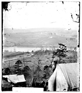
    knoxville in the distance


    environs of knoxville seen from south bank of tennessee river, east tennessee university in middle distance - knoxville, tennessee: photo compliments of the us library of congress, american memory collection

    on a trip home to harriman, tn, a couple of weeks ago, we stopped as we always do at the tennessee state line visitor's bureau to check the brochures and maps available this fall. this stop, we got a gem: a path divided, tennessee's civil war heritage trail, written by dr. wayne c moore of the tennessee state library and archives and published by the tennessee wars commission. the glossy 47-page booklet outlines not only tennessee's major battles but the state's role in the confederacy. it contains concise background histories, battle summaries, timelines, and a fold-out map.

    some good news is that i've just discovered that the entire booklet is available online for download.

    this is a terrific resource for tennessee genealogists.

    though brief, the booklet offers insight and leads for those of us researching individuals and families whose history includes tennessee and the civil war era. the booklet's brevity is actually one of its major strengths. it can be read in its entirety in one sitting. it is well organized: a historical prologue is followed by sections on the state's invasion by river; the fight for west tennessee; the contest for middle tennessee; and east tennessee's mountian war. it is highly readable without being condescending.

    i love that now i can have an electronic copy handy on my hard drive for instant reference.

    the free electronic version (a pdf file) can be downloaded from
    here .

    and if you're in a civil war sort of mood today, check out the civil war preservation trust mentioned in the booklet. a link to the preservation trust website is
    here |.
    posted by picasa

    Sunday, August 13, 2006

    tennessee county formation maps for census work

    roane county boundaries 1810


    tennessee county formation maps and formation information - helpful for census and migration use - can be found as ani-maps online | here |

    with the map on this page, you can follow a county year to year with three different kinds of county outline maps:

    1. plain outline maps can be shown with changing boundaries for each county from census to census. roane county was established in 1803 and can be followed from 1810 forward, for instance.

    2. outline maps of any census year with an outline map of the county during the previous census as an overlay, permitting you to see additions or subtractions to the boundaries.

    3. outline maps of any census year with an outline map of the county during the next census as an overlay, permitting you to see future additions or subtractions to the county's boundaries (similar to #2 above). click on 1840 map, for instance, to see the changes in roane county's boundaries between the 1840 and 1850 censuses.

    near the bottom of the page, there's a quick recap of census information for tennessee - which federal censuses are available - which years and which counties.